Levels - Contour Maps
The Levels page in the Property Manager includes the levels properties for a contour map.
|
|
|
Set the contour level properties in the Levels page. |
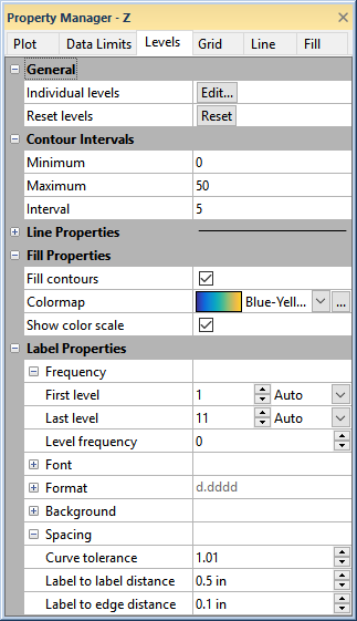
General
The General section includes properties for setting individual levels properties and returning the levels to default. Click Edit in the Individual levels field to edit individual levels in the Levels dialog. Click Reset in the Reset levels field to return the levels to their default properties.
Levels Dialog
The Levels dialog controls the display of individual contours, contour lines, and color fills on the contour map. The contour level list shows the contour levels to be displayed on the map.
|
|
|
Use the Levels dialog to control the display of contour levels, line, and fill properties. |
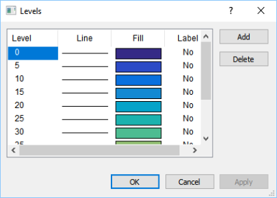
Double-click any of the elements in the list to set parameters for a specific contour level.
- Double-click an individual level value to open the Set Level dialog.
- Double-click an individual line sample or fill color box to open the line and fill properties in the Line/Fill Properties dialog.
- Double-click and individual level label setting to toggle the label display on (Yes) or off (No).
Add
Click the Add button to open the Set Level dialog. You can define a new level and the level is added to the Levels dialog in the appropriate position.
Delete
Click the Delete buttons to delete the currently selected contour level.
Contour Intervals
The Contour Intervals section includes properties for quickly setting the contour level range and interval.
Minimum and Maximum
Enter values for the Minimum and Maximum contours in the Contour Intervals section. To change the value, highlight the existing value and type a new value.
Interval
Enter an Interval value to define the spacing in Z units between adjacent contour lines. To change the value, highlight the existing value and type a new value. Contours will automatically be created with the desired Interval as the spacing.
Line Properties
Set the line properties for the contour levels in the Line Properties section.
Fill Properties
The Fill Properties section includes options for adding a color fill to the contour map and applying the color fill from a color gradient.
Fill Contours
Select the Fill contours property to add a color fill to the contour map.
Colormap
Set the color gradient for the color fill by selecting a predefined gradient in the Colormap field or click the  button to create or modify a one in the Color Gradient dialog.
Show Color Scale
Select the Show color scale property to add a color scale to the plot window. Clear the Show color scale property to remove the color scale.
Label Properties
The Label Properties section includes the frequency, font, format, background, and spacing properties for the contour level labels. See the Labels topic for more information on the frequency, font, format, and background properties. The following information is specific to contour level spacing.
Curve Tolerance
Curve tolerance specifies the maximum amount of contour curvature allowed when placing labels on contour lines. Curve tolerance is calculated by dividing the actual distance along the contour line by the straight-line distance between the end points of the contour label. Highly curved lines might not be labeled automatically. You can increase the curve tolerance value to allow labels on highly curved contour lines, although contour labels might be hard to read. The default Curve tolerance value of 1.01 should be acceptable in most cases.
Label to Label Distance
Label to label distance specifies the minimum distance (in inches or centimeters) between labels along the contour line. Grapher searches for the next suitable location for a label after moving the minimum distance specified by the Label to label distance. The next label is not drawn until a segment of the necessary length within the curve tolerance limits is found. As the Label to label distance is increased, fewer labels are drawn on the contours.
Label to Edge Distance
Label to edge distance specifies the minimum distance (in inches or centimeters) from the label to the edge of the map. This feature controls label placement so labels do not overwrite the map borders or axes.