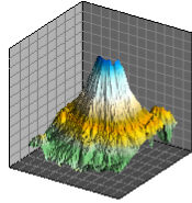
Surface Grid Map
|
Click the Home | New Graph | Contour Surface | Surface Grid Map command to create a surface grid map. Surface grid maps are created from grid files, types of which include .GRD, .DEM, .DDF, .HDR, and .DTED. If your data is in a regular array of Z values, you may convert it to an ASCII .GRD file format. Click the Surface Grid Map command to create a surface map from a grid file. |
|

|
| A surface grid map is created from a grid file. |
Creating a New Surface Grid Map
To create a surface grid map:
- Click the Home | New Graph | Contour Surface | Surface Grid Map command.
- Select a grid file in the Open Grid dialog. You can select a new grid file or you can select an open data file in the Open grids section.
- Click the Open button. A surface grid map is created using the default properties.
Editing Surface Grid Map Properties
To change the features of the surface grid map, select the surface grid map and edit its properties in the Property Manager. Click the following tabs in the Property Manager to change different properties:
