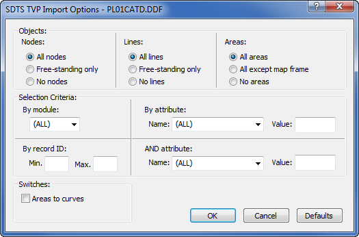
SDTS Topological Vector Profile .TVP Import Options Dialog
Select any .DDF file to open the Import Options dialog.
|
|
|
Customize the import options in the SDTS TVP Import Options dialog. |
Nodes Options
These options determine which Node items are imported. If All nodes is selected, all nodes in the SDTS data set are imported. If Free-standing only is selected, only those nodes that are not associated with an area or line are imported. If No nodes is selected, none of the nodes are imported.
Lines Options
These options determine which Line items are imported. If All lines is selected, all lines in the SDTS data set are imported. If Free-standing only is selected, only those lines that are not associated with an area are imported. If No lines is selected, none of the lines are imported.
Areas Options
These options determine which Area items are imported. If All areas is selected, all areas in the SDTS data set are imported. If All except map frame is selected, the areas that make up the outline of the map will not be imported. If No areas is selected, none of the areas are imported.
Some SDTS data sets supplied by USGS contain a map frame that is expressed in the data set as a normal polygon instead of an "invisible" polygon (i.e. a "PC" entity instead of a "PW" or "PX" entity in SDTS terminology). In such cases, the All Except Map Frame control will have no effect.
By Module List Box
If the name of a specific module is selected, imported items will be limited to those that reside in the specified module. If (ALL) is selected, items will be imported from all modules in the SDTS data set.
By Record ID Edit Boxes
Each item in the SDTS dataset has a unique record ID number. To import only those items within a specific range of record IDs, enter the lowest desired record ID number in the Min edit box, and the highest desired record ID number in the Max edit box.
By Attribute, AND Attribute Controls
Application-specific attributes are associated with some items in an SDTS data set. To import only those items that have a specific attribute, select the name of the desired attribute in the Name list box and enter the value of the desired attribute in the Value edit box. If (ALL) is selected in the list box, items will be imported without regard to attributes. If both By Attribute and AND Attribute are specified, only those items that have both of the specified attributes will be imported.
Areas To Curves Check Box
If this is checked, any areas in the data set will instead be imported as lines (curves) instead of polygonal areas.
Defaults Button
The Defaults button resets the Import Options to default values. The default options direct the Import Filter as follows: Import free-standing nodes, import free-standing lines, import all areas, don't limit by module, record ID, or attribute, don't import areas as curves, and don't synthesize Ids.
SDTS Topological Vector Profile Import Filter Messages
The following messages may appear while importing SDTS Topological Vector Profile files.
Expected SDTS TVP data. Found SDTS DEM or raster
This error message:
The import file appears to be in an unrecognized format. Make sure the file is a properly formatted SDTS Topological Vector Profile file.
may appear if the selected .DDF file is in the incorrect format. If you receive this message after choosing Data | Edit | Open Data, you likely have a SDTS DEM file. Try using the Home | New Graph | Contour Surface | Contour Grid Map command instead.
