Golden Software Blanking .BLN Export Options Dialog
The Export Options dialog allows you to specify options which determine how information in the file is exported. When exporting, the application specifies coordinates in Page Units (inches or centimeters) as indicated on the document rulers. You may want these values offset and/or scaled back to original map coordinates in the Golden Software Blanking .BLN file. The scaling options can be changed on the Scaling tab.
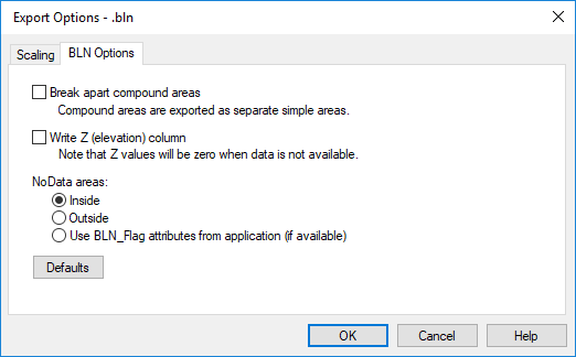
|
| Specify the BLN export options in the Export Options dialog. |
Break Apart Compound Areas
Choose Break apart compound areas to have compound areas (those containing islands or lakes) output as separate area entities. This option should be chosen if the .BLN file is to be used as a boundary file. Do not choose this option if the .BLN file is to be used as a blanking file.
Write Z (elevation) column
Grapher does not associate Z values with objects. The third column will always contain 0 when Write Z (elevation) column is checked. Check the Write Z (elevation) column check box to export the .BLN file with the Z values. If ZLEVEL values are not available for the object, 0 will be written in the Z column.
NoData Areas
The NoData areas section contains the option to set the BLN file blanking flag to either assign NoData values inside or outside. Select the appropriate option. With a simple BLN file with a single polygon, the blanking flag is located in cell B1. A zero (0) is displayed when assigning the NoData value outside the area and a one (1) is displayed when assigning the NoData value inside the area. The NoData areas option sets the blanking flag for all polygons in the BLN file.
Polygons do not have associated attributes in Grapher. When Use BLN_Flag attributes from application (if available) is selected, the blanking flag is set to 1 for assign NoData inside.
Defaults
The Defaults button sets all options to default conditions.
Scaling Page
When exporting, the application specifies coordinates in Page Units (inches or centimeters) as indicated on the document rulers. You may want these values offset and/or scaled back to original map coordinates in the Golden Software Blanking (BLN) file.
This is accomplished by specifying the corner points of a rectangle (in Page Units) in the application document and the corner points of a rectangle in the desired BLN file units. The document coordinates will be offset and/or scaled so the corner points of the document rectangle will have the desired BLN coordinates. Checking Save scaling info will cause the scaling information to be stored for future use.
Scaling information can be retrieved from two sources. Saved will reload previously saved values. Application will load scaling info calculated by the application. The application provides potentially useful scaling info whenever possible. If the application detects an unrotated 3-dimensional map object that is viewed from directly overhead (i.e., it’s really a 2-D map object) and that map object is the only object being exported, it retrieves the (X,Y) data extents from the map and makes those the BLN scaling rectangle. Otherwise, the application sets the scaling rectangles so the BLN coordinates will be the same as the document page units.
See the Scaling Page for detailed information.